Updated on • 22 Oct 2024
DJI Removes Majority Of Its Drone Geofencing Restrictions
Discover how DJI's removal of geofencing restrictions enhances drone accessibility and operational flexibility across the UK and Europe.
DJI removes the majority of its geofencing restrictions in the UK and throughout Europe;
DJI's GEO system has been updated with UAS geographical zone data from national aviation authorities;
The move will provide more freedom to fly in some areas without requiring an unlock from DJI. But pilots are urged to abide by local drone rules and regulations;
DJI says it has updated the GEO system to align with existing drone regulations set by EASA and the UK CAA;
The update applies to most of DJI's consumer, enterprise, and agricultural platforms.
DJI has removed the majority of its geofencing restrictions in the UK and throughout Europe, to align with existing drone regulations set by European Union Aviation Safety Agency (EASA) and the UK Civil Aviation Authority (UK CAA).
The world’s leading civilian drone manufacturer is updating its GEO system - which delineates where it is safe to fly and where flight may raise concerns - with UAS geographical zone data from national aviation authorities.
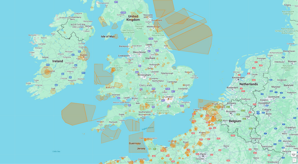
It means that operators will now follow localised flight-map information and restrictions stipulated by the aviation authority for the country that the drone is being flown in, rather than those suggested by DJI.
In some cases, DJI geofencing recommendations prevented a drone from flying in a specific area, or limited flight, and the operator would need to unlock permission to operate in these zones.
Now, the majority of DJI’s geofencing restrictions and recommendations have been removed from the DJI Fly, DJI GO 4, and DJI Pilot apps, as well as DJI’s own Fly Safe website - providing operators with more freedom to fly, without requiring an unlock from DJI.
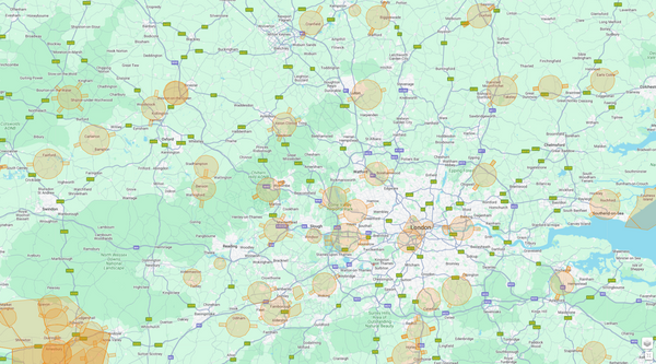
However, remote pilots are reminded that they must still adhere to local drone regulations, maintain compliance and safety, and ensure they have the latest version of the relevant UAS geographical data before conducting any operation.
The geofencing systems to be removed by DJI include:
Zone | Description |
Red Restricted Zone | In these zones, which appear in red on the map, users will be prompted with a warning and flight is prevented. If you believe you have the authorisation to operate in a Restricted Zone, please contact flysafe@dji.com or request for Online Unlocking. |
Blue Authorisation Zone | In these zones, which appear in blue on the map, users will be prompted with a warning and flight is limited by default. Authorization Zones may be unlocked by authorised users using a DJI verified account. |
Grey Altitude Zone | Altitude zones will appear in grey on the map. When flying in these areas, users receive warnings in DJI app, or flight altitude is limited. (Example: zone in grey near an airport) |
Yellow Warning Zone | In these zones, which may not necessarily appear on the map, users will be prompted with a warning message. (Example: Class E airspace) |
DJI has said that it will show an orange Enhanced Warning Zone (whereby the operator will be prompted by the GEO system at the time of flight to unlock the zone, but does not require a verified DJI account or an internet connection at the time of flight to do so) to reflect Flight Restriction Zones/No Fly Zones in accordance to official data provided for each country, ie at sensitive sites such as airports.
This can be seen in the following examples.
The image below shows how previously, before the update, the area around Gatwick Airport had multiple DJI geofencing zones in place - such as Restricted Zones; Altitude Zones; Warning Zones, Authorisation Zones, and Enhanced Warning Zones.
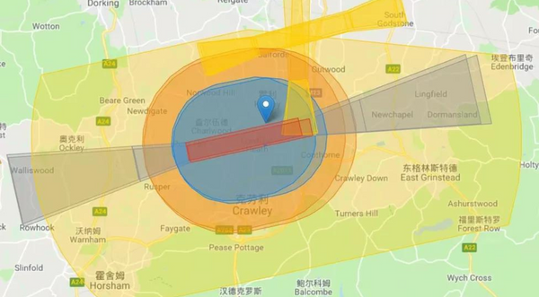
But now, the updated GEO Zone map on the Fly Safe website shows that the majority of these geofenced areas have been removed. Only an Enhanced Warning Zone - which covers the Flight Restriction Zone for the airport and runway extensions, as stipulated by the CAA - appears.
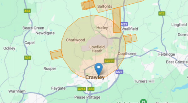
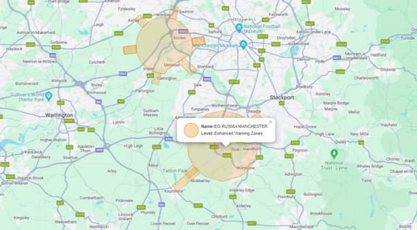
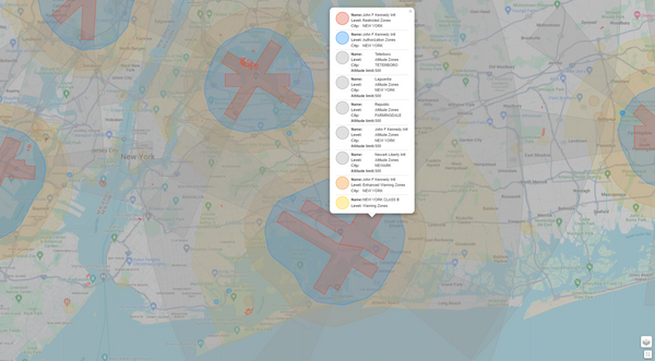
And these next images show the difference in geofencing restrictions between the UK - where the map data has been updated - compared to the USA, where DJI’s geofencing restrictions still exist.
The area surrounding Manchester Airport shows the Flight Restriction Zone around the airport, and is flagged as an Enhanced Warning Zone…
…whereas the area covering John F Kennedy International Airport has Restricted Zones, Altitude Zones, Authorization Zones, and Warning Zones.
In a statement, DJI said: ‘As of January 2024, in adherence to European drone regulations, all drone manufacturers are required to enable users to download and display UAS geographical zone data from the national aviation authorities of EASA member states.
‘DJI was the first civilian drone manufacturer to adopt the GEO system voluntarily to protect airports and highly-sensitive national security sites in 2013.
‘At the time, mass produced small consumer drones were new and aviation authorities needed time to put appropriate safeguards in place. GEO system helped prevent DJI drone operators from inadvertently flying inside controlled airspace.
‘Global regulations have advanced significantly since then.’
While the UK is no longer part of the EU, a document published by the UK CAA in October 2023 - entitled Remotely Piloted Aircraft Systems (RPAS) Geo-Awareness - states that UAS operators should have the latest version of the geographical zone data.
The update encompasses most of DJI's consumer, enterprise and agricultural models. To remove the GEO zones, connect the drone and the remote controller and open the flight app to update the Fly Safe data online.
For older models - such as DJI Phantom 3 Series and older; DJI Inspire 1; and DJI Matrice 100 and 600 - users can submit an unlocking request without uploading an authorisation file to unlock a restricted zone.
Initially, the update will be introduced in countries that have implemented geographical maps that are compliant with existing technical standards, such as the UK, as well as Belgium, Bulgaria, Cyprus, Denmark, Germany, Ireland, France, Lithuania, and Switzerland.
Other countries under EASA jurisdiction will follow in due course.

written by
James Willoughby
James joined heliguy™ in 2018 following a 13-year stint in print and online journalism, having worked on regional and weekly newspaper titles. He is responsible for spearheading heliguy™'s content strategy and social media delivery. James collaborates with DJI Enterprise's European marketing team to coordinate and produce case studies and helps organise events and webinars.