News
M300 RTK and L1 Case Study - Exclusive LiDAR Data Sets
Exclusive data sets collected by heliguy™ show the quality of the DJI Zenmuse L1 for LiDAR drone surveying, and the power of DJI Terra as a data-processing software tool. View the point cloud data sets. ... Read More

Exclusive data sets collected by heliguy™ show the quality of the DJI Zenmuse L1 for LiDAR drone surveying, and the power of DJI Terra as a data-processing tool.
Key findings from our sample data sets include:
The L1 is capable of creating dense point clouds, like the one above;
Rapid data processing through DJI Terra: Three minutes to process flight data from a 30-minute mission;
Autonomous data collection makes the L1 an accessible and simple plug-and-play LiDAR solution;
The L1 helped to identify intricate details on our point clouds, such as powerlines; features which were not visible in a 2D orthomosaic;
The L1 features a LiDAR sensor and an RGB camera: Enables L1 to output true colour point clouds and reality models.
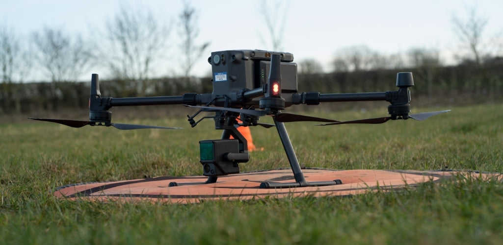
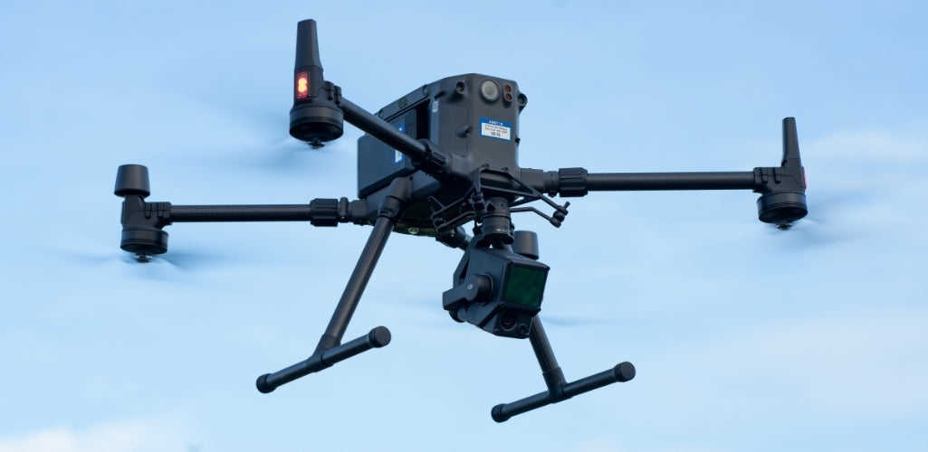
Recently released, the L1 is DJI's first aerial LiDAR payload, engineered exclusively for flagship commercial drone, the DJI M300 RTK.
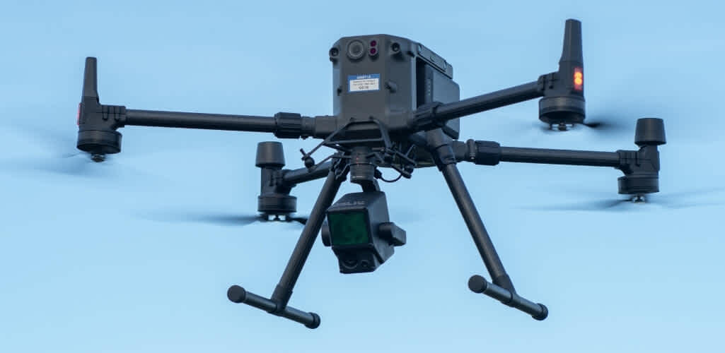
To gauge the quality of this set-up for aerial surveying, we conducted a single autonomous flight mission to collect some sample data sets, post-processed through DJI's drone surveying software package, Terra.
Ben Sangster, GIS and Survey Lead at heliguy™, was impressed with the results.
He said: "The L1 is a comprehensive LiDAR solution which helps to build high-density point clouds. When we saw the specifications of the L1, we were impressed, and the sensor duly delivered in the field.
"We ran the collected data through DJI Terra; which was simple to use, extremely quick to process the data, and helped to produce effective point-cloud models.
"The quality of both the collected data and the processing ensures that you have a reliable end-to-end LiDAR survey solution, built within the DJI ecosystem for streamlined workflows and comprehensive results."
RELATED CONTENT: A Guide To Drone LiDAR
Autonomous LiDAR Data Collection
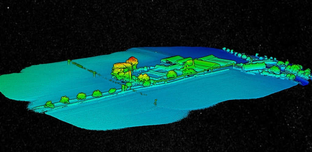
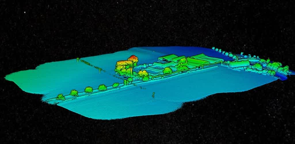
heliguy™ tested the M300 RTK and L1 sensor at a farm in Warkworth, Northumberland, UK; the site pictured below as a point-cloud model, generated by the L1 and Terra.
One autonomous flight was conducted. For this, we selected a Standard Mapping Mission within the DJI Pilot app and then drew a custom polygonal flight zone on the screen to mark the boundaries of the survey area. The overlap rate was set at 20%. The D-RTK 2 mobile station for the DJI M300 RTK was also set up to gather more accurate positional data to supplement the L1's inertial measurement system.
Then the mission began. It demonstrated how easy the L1 is to deploy for effective and efficient LiDAR data collection.
Ben said: "The L1 was released in response to the burning demand from drone operators in the AEC and surveying industries for a powerful yet accessible LiDAR drone solution - and our flight proved that the L1 is exactly that.
"The ease at which the mission was conducted - by choosing the same Standard Mapping Mission as you would to capture a run-of-the-mill 2D orthomosaic, and then autonomously deploying the M300 RTK and L1 - showed how seamless this combination is for data collection.
"Traditionally, the complexities and high costs associated with deploying LiDAR has limited its use as an aerial surveying drone technique, but the simple-to-use L1-M300 RTK pairing has changed this dynamic, bringing an accessible and cost-effective LiDAR solution to the market. I think it will spark a major breakthrough in democratising LiDAR drone technology."
L1 Point Clouds - Density
The L1 may be a highly-accessible LiDAR tool, but what of the quality of the data collected?
Judging by our sample data sets, the sensor helped to create some robust point-cloud models.
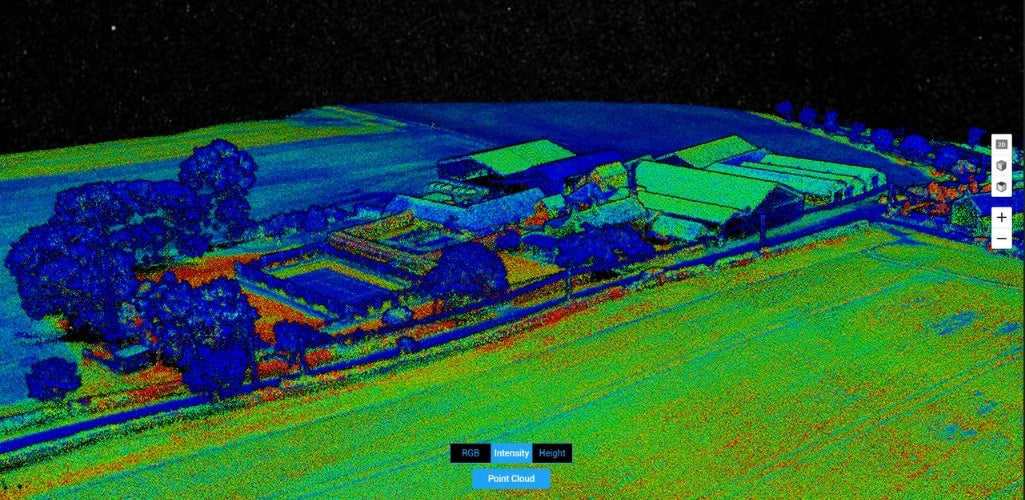
For instance, this image below shows a fairly complete recreation of the survey site - especially when reviewing the tops of the buildings, which appear dense and fully-formed.
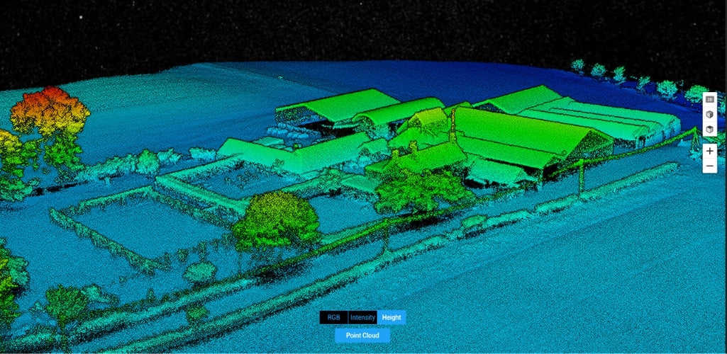
Admittedly, there are areas of the model which aren't quite as comprehensive, such as the sides of the barns, but this is down to the fact that the gimbal was fixed at a 90° angle for the duration of the flight. This made it more difficult to capture a dense set of points to fully flesh out the side profiles of the buildings.
However, a reorientation of the gimbal would significantly improve the intensity of the point cloud in these areas.
Ben said: "The L1 data sets show a dense and robust model. Even though the camera was fixed at 90°, the L1 was still able to capture sections of the sides of the farm buildings - thanks, in part, to the sensor's 70° field of view.
"Yes, there are parts which aren't fully-formed, but as we've established, the gaps that do appear were due to the gimbal position. But, with any sort of tilt of the camera - such as at 70° - a very dense covering of the building façades would have been obtained, further increasing the completeness of our point clouds."
Unlike most other drone LiDAR systems, the L1 is an out-of-the-box 3-axis-stabilised solution, meaning that any inadvertent rotational movement of the drone (tilt, roll, and pan) is dynamically stabilised within ±0.01°, enabling homogeneous point distribution, even at very high scan rates.
As such, the risk for data gaps goes down significantly and enables accurate geo-referenced data-gathering missions.
Intricate Data Collection
With a detection range of up to 450 metres, the L1 delivers an effective point rate of 240,000 points per second. However, as the module allows up to 3 returns per laser shot, the point rate can climb to 480,000 points per second.
On top of this, the L1 is the only aerial LiDAR sensor to support both a line scan mode and a non-repetitive scanning pattern. This means that, as the integration time grows, so too does the area being scanned inside the field-of-view (FOV).
This in turn increases the likelihood of objects and other details within the FOV being detected.
Both of these features make it easy for data analysists to pick out and classify different types of objects in a point cloud, such as overhead wires - which can be missed using alternative LiDAR solutions, or indeed, alternative surveying techniques, most notably photogrammetry.
This was certainly the case when reviewing the L1 data sets. For instance, this L1 height model picks up intricate details, such as the power lines to the front of the property - pictured here to the middle centre of the image.
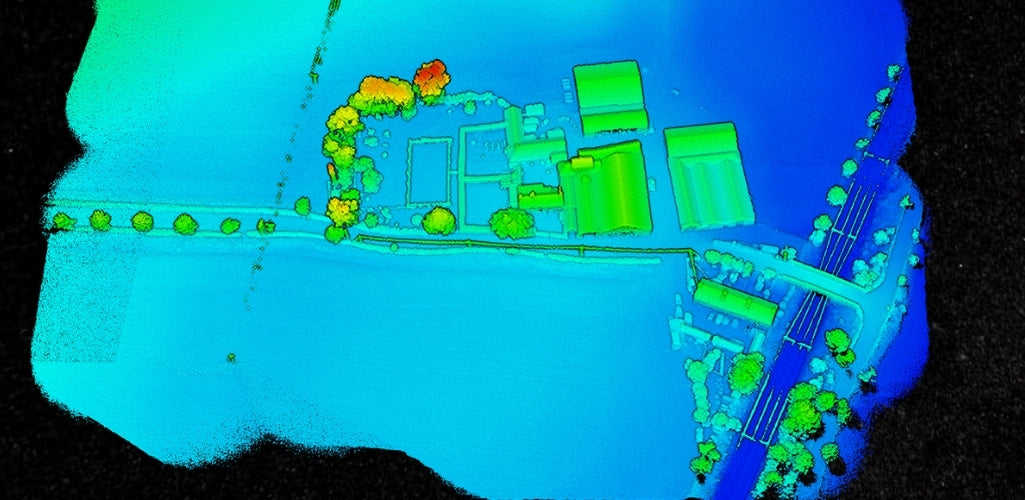
Now compare this with a 2D orthomosaic (generated by the Zenmuse DJI P1 photogrammetry sensor) of the same site. The power lines are not visible, because they are too small to be picked up through photogrammetry techniques - showing the value of LiDAR, and more specifically, the L1, for picking up intricate details.
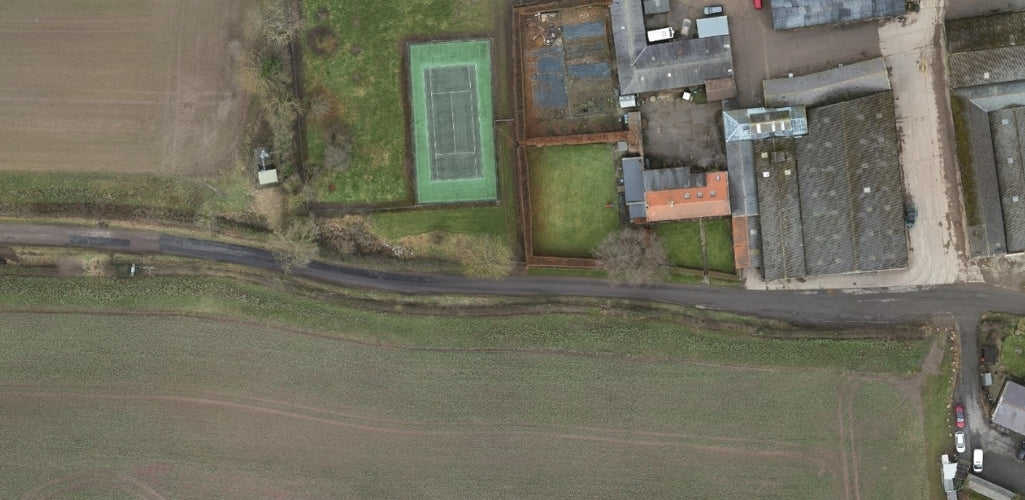
As well as picking up small details, the L1's multi-return capability empowers drone LiDAR users to easily generate the elevation data in dense forest fields and extract it into DEM and DSM.
This is typical of LiDAR technology - and another advantage of using it over photogrammetry, as LiDAR uses pulses which can penetrate gaps between leaves and branches to reach ground level.
In contrast, in traditional photogrammetry, vegetation can stop you from acquiring an accurate representation of what the ground topography looks like.
RELATED ARTICLE: LiDAR Vs Photogrammetry For Drone Surveys
L1 Point Clouds - True Colour Point Clouds
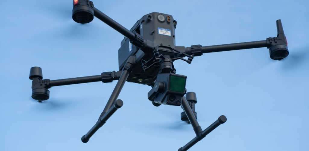
The L1 integrates an RGB camera alongside its LiDAR sensor, as seen in the image below.
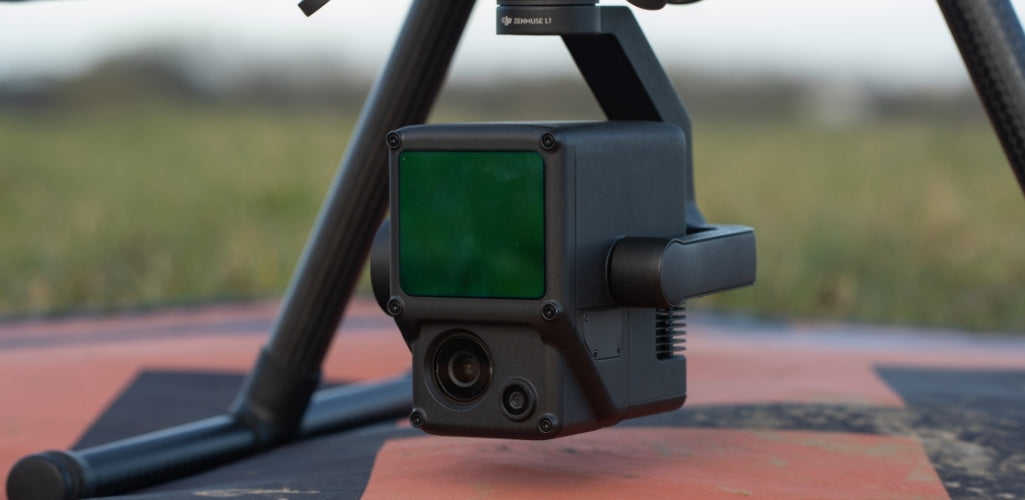
This has numerous advantages.
The first is that the RBG camera - which provides functions for taking photos and recording videos - enables the L1 to generate real-time colour information for the point cloud data during the scanning process. This allows the L1 to output true colour point clouds and reality models.
Typically, LiDAR models are not coloured, so the L1 removes the need to spend extra time and money obtaining true-color point cloud models.
The L1's colour modes are:
True colour
Colouring by reflectivity
Colouring by elevation
Equally, when it comes to post-processing, DJI Terra supports the following colour modes:
Visible
Reflectivity rate
Altitude
Return numbers
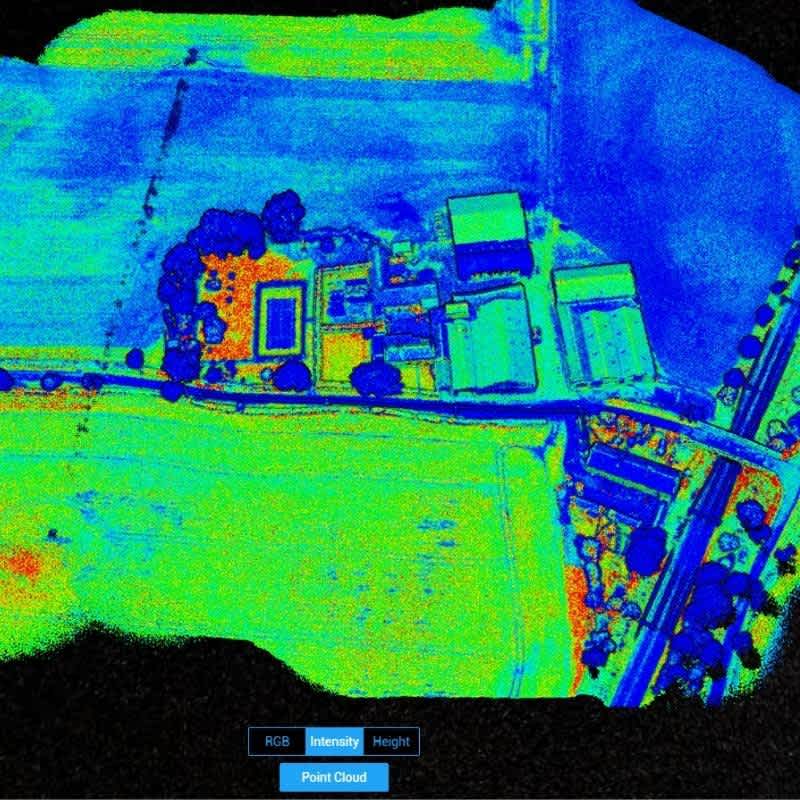
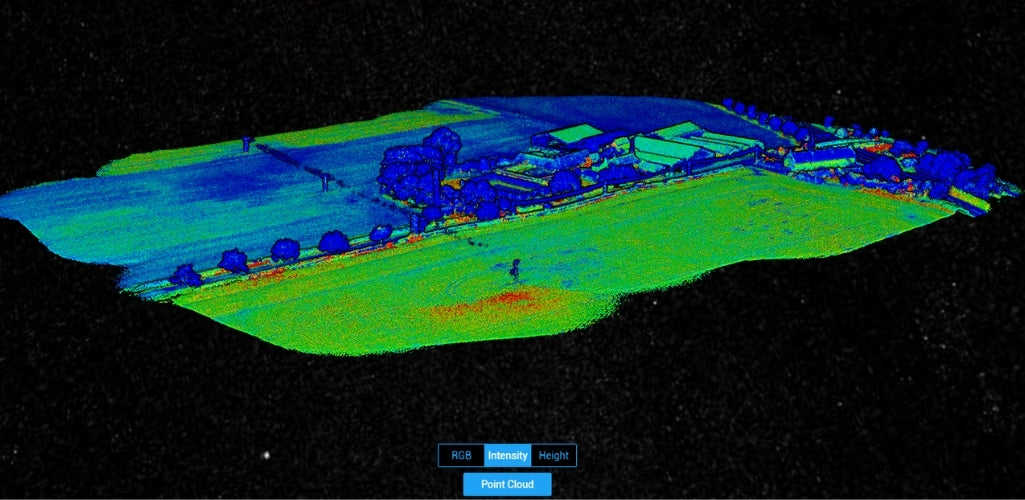
The image below shows an L1 reflectivity model - built by recording the intensity of the laser beam's return strength. A low number indicates low reflectivity, while a high number indicates high reflectivity.
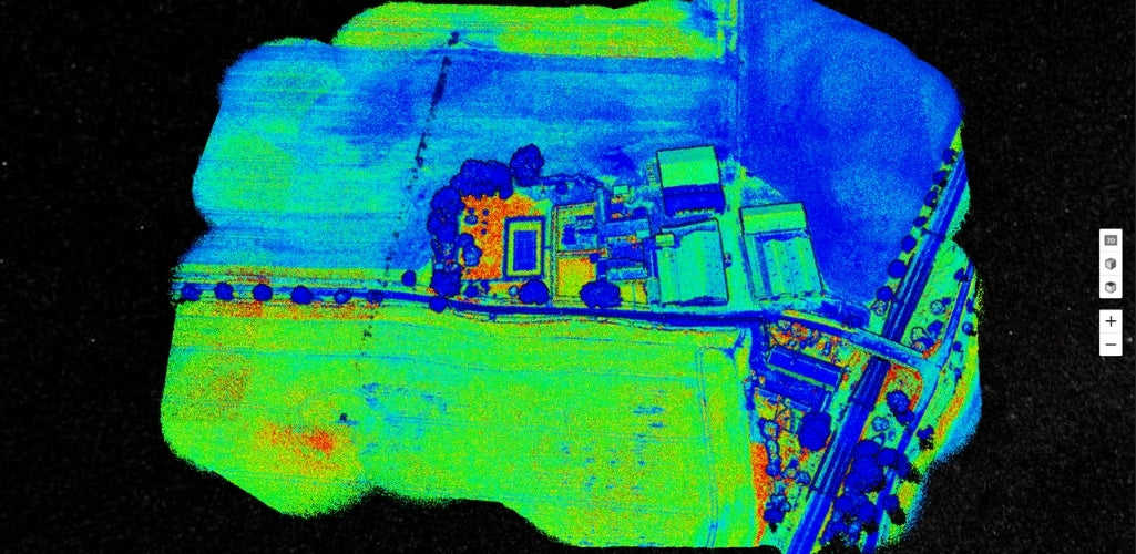
This is useful for numerous applications, such as land cover classification.
For instance, look how the intensity model identifies differentiations in the vegetation around the farm - with the bottom field mostly green, while the top field is mostly blue.
Notice, too, the small pocket of red in the bottom field; a difference in intensity which could force an observer to review this more closely to make decisions based on this data; information which would not have been obvious with the naked eye.
A quick look at the orthomosaic of the same site shows how the vegetation does indeed differ - with a denser covering at the bottom - which is thus reflected on the LiDAR data set.
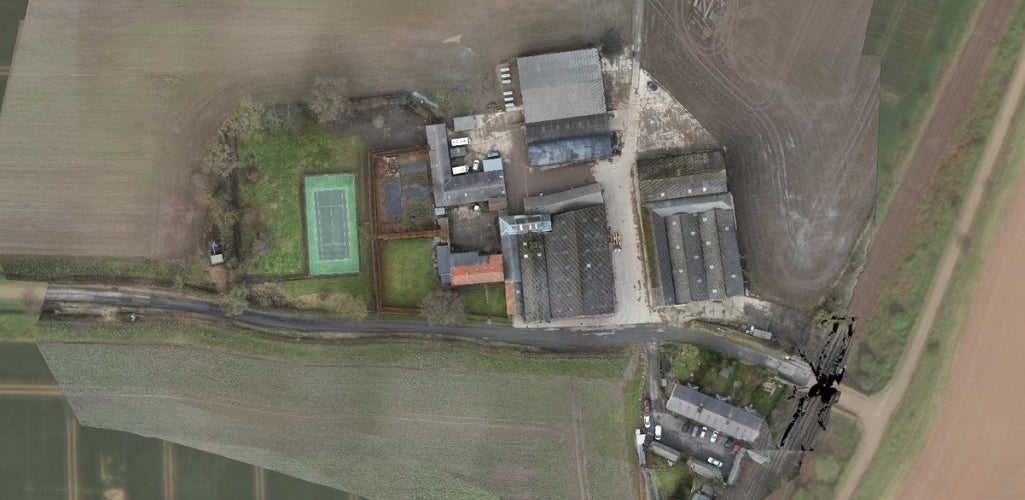
For instance, one of the benefits of photogrammetry is that it provides instantly recognisable and accessible maps of a survey area; after all, photogrammetry creates models based on hundreds or thousands of real-world images which are stitched together.
Not only does this help to access and understand digital twins quickly and easily, it also takes the abstract out of the LiDAR data set.
For example, compare these two images of the farm in Warkworth - the 2D orthomosaic shows the tennis court and various vehicles; features on the map which are almost impossible to clearly distinguish on the LiDAR point cloud.
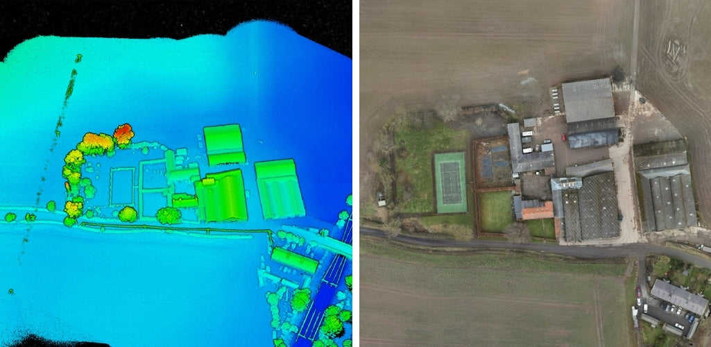
Being able to compare the data sets is extremely useful.
Likewise, the ability to use the L1 to access real-time point clouds through Point Cloud LiveView is extremely beneficial, providing immediate insights onsite. You can also verify fieldwork quality by checking point cloud data immediately after each flight.
This ensures you are capturing the best data possible, and enables you to collect further data if needs be.
For instance, going back to the side profile of the buildings; you could see that these needed fleshing out, so could set the camera at an alternative angle to build denser points for these sparsely-populated areas. You could also capture additional data through a manual flight.
The L1's RGB camera is a 20MP 1-inch CMOS Sensor, with mechanical shutter to eliminate rolling shutter distortion.
In fact, it is the same sensor as the one on the DJI Phantom 4 RTK - DJI's dedicated low-altitude photogrammetry solution. So, just like the P4 RTK, the L1 can achieve a ground sample distance (GSD) of 2.74 cm at 100 metres flight height, should you choose to use it for photogrammetry.
DJI Terra For Post-processing L1 LiDAR Data
The L1 is compatible with DJI Terra. This means that you can combine the L1, M300 RTK, D-RTK Base Station, and Terra for a fully-integrated and complete DJI solution for accurate real-time data acquisition and post-processing.
In fact, DJI Terra provides a one-stop-shop for post-processing. This software package fuses the IMU (inertial measurement unit) and GNSS data for point cloud and visible light calculations, as well as conducting POS data calculations to enable effortless generation of reconstruction models and accuracy reports.
High-Accuracy IMU
Before we delve into DJI Terra, let's address the issue of the IMU.
The L1 has a high-accuracy IMU, which measures the drone's real-time 3-axis acceleration and angular velocity. This calculates the aircraft’s speed, position, and altitude angle.
A high-accuracy IMU is pivotal for quality LiDAR data collection because, without it, your point cloud would be nothing but an arbitrary collection of points.
In typical operating scenarios, the L1 delivers IMU accuracy of 0.025°(roll/pitch)/0.08°(yaw). For further reliability and precision, a vision sensor for positioning accuracy and a dual-frequency GNSS receiver have been incorporated into the solution. This allows the L1 to deliver a relative survey-grade accuracy of 5cm and absolute accuracy of 10cm while flying at an altitude of 50m.
During our mission, we did not use any check points or a GPS to validate these accuracies, but the specs suggest it is a highly-accurate solution.
As a side note, the M300 RTK completed several figure of eight maneuvers, pre and post data collection during our mission, to calibrate the IMU.
DJI Terra - Highly-efficient LiDAR Data Processing
One of the things that struck us was the speed at which DJI Terra processed the data back in the office - taking just three minutes!
By any stretch, that is quick - but this rapid timeframe is put firmly into perspective when compared with the time it took Terra to process our photogrammetry data with the P1 sensor: Up to 12 hours!
One of the key reasons for this is because, unlike in photogrammetry, the software does not need to find the same point in multiple images and reconstruct it every time; rather, LiDAR represents direct measurements, and thus reduces the processing time.
In terms of data, the L1 stores the raw information in .dat format. Once processed through Terra, it is converted into .las format, which is a standard point cloud format.
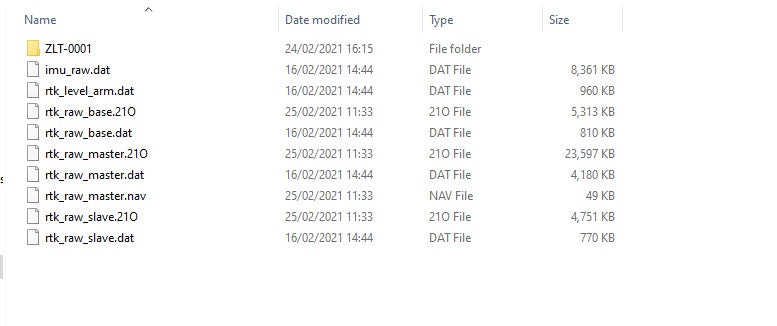

This raw data is processed alongside all of the RTK and IMU positional data to produce an accurate output.
Ben said: "The processing time took around 3-4 minutes - which is far quicker than anything seen with photogrammetry. It was staggering to see the speed of Terra; the processing time for an area of around 250 x 250 metres was very quick.
"After all, processing photogrammetric data collected with the P1 through Terra of the same area took around 12 hours, therefore, the final products from the L1 were obtained much quicker - and the quality of the data sets created by Terra speak for themselves."
One thing to note is that the raw positional and LiDAR data files do always need to be processed through Terra as laser scanned data is specific to the developer and can not be processed in third-party apps.
DJI has said there is scope for third party apps to become compatible with their initial data processing, so watch this space.
Efficient LiDAR Solution
The speed of DJI Terra epitomises the M300 RTK, L1, and Terra an an efficient end-to-end solution.
The M300 RTK has incredible endurance (up to 55 minutes of flight time), and when paired with the L1, it can enable a highly-efficient method of aerial surveying data capture, covering up to 2km² in a single flight from 100m altitude.
Our survey area was a lot smaller; flying at a height of 80m, we covered 250m x 250m in half an hour, which included IMU calibration time.
Ben said: "The L1 is an efficient solution for aerial surveying. Ours wasn't a huge site, but the L1 would show its worth over larger surveying areas. Combine this with the processing speed of Terra, and you have a highly efficient and effective ecosystem."
Both the L1 and M300 RTK are IP-rated, meaning both can perform in testing weather conditions and widening the opportunity for data collection. The M300 RTK is IP 45 rated, while the L1 is IP54. The drone and the camera have an operating temperature range of -20°C to 50°C.
REALTED ARTICLE: An IP Rating Guide And How Waterproof Is The M300 RTK?
L1 and M300 RTK Case Study - The Verdict
Traditionally, integrating LiDAR with drone technology has proven a tough nut to crack.
From the lack of lightweight, inexpensive, and highly functional solutions, through to the complexities of post-processing the data and the unique skill set required to interpret the seemingly daunting data sets, drone LiDAR has been an under-used surveying technique.
DJI sought to address this with the L1; an accessible, compact, cost-effective, and autonomous LiDAR solution which widens the scope of LiDAR for drone operations.
In fact, it epitomises DJI's stance on the drone industry as a whole - innovative, out-of-the-box solutions which are efficient, effective, and easy to use.
With its ability to create detailed and dense point clouds, coupled with the ability to process the data within Terra for a streamlined end-to-end DJI workflow, the L1 appears to be an exciting proposition for aerial surveyors, pushing LiDAR into the mainstream.
Click to inquire about the L1 with heliguy™ or call us on 0191 296 1024.
