Technical
RTK Vs PPK For Surveying
In-depth guide comparing RTK (real-time kinematic) and PPK (post-processed kinematic) for surveying, including drone mapping. Find out the differences between the two methods to help you choose the right one for your surveying application. ... Read More

Find out the differences between RTK and PPK and how they help surveying, including drone mapping;
Both surveying techniques are GPS correctional technologies which can help to achieve cm-level positional accuracy;
RTK and PPK use observations from GNSS receivers, such as industry-leading solutions from Emlid;
RTK applies positional corrections in real-time, while PPK resolves errors after data collection;
Both methods have advantages and disadvantages: Learn the pros and cons of each and choose the right one for your specific mission.
If you're thinking of conducting a drone surveying mission, chances are you will have heard of RTK and PPK.
After all, some of the best known drones on the market carry these letters in their title, such as DJI'S M300 RTK and Phantom 4 RTK.
But what exactly is RTK and PPK? What do they mean, what do they do, and which one should you use?
Find out in this in-depth guide.
RTK And PPK: What Is The Difference?
RTK (real-time kinematic) and PPK (post-processed kinematic) are GPS correctional technologies which help to collect highly-accurate data.
They use observations from two GNSS receivers - such as the Emlid Reach RS+ or Reach RS2 - to achieve cm-level positional accuracy.
Therefore, such receivers are irreplaceable when it comes to surveying and other applications where you need to know your exact position.
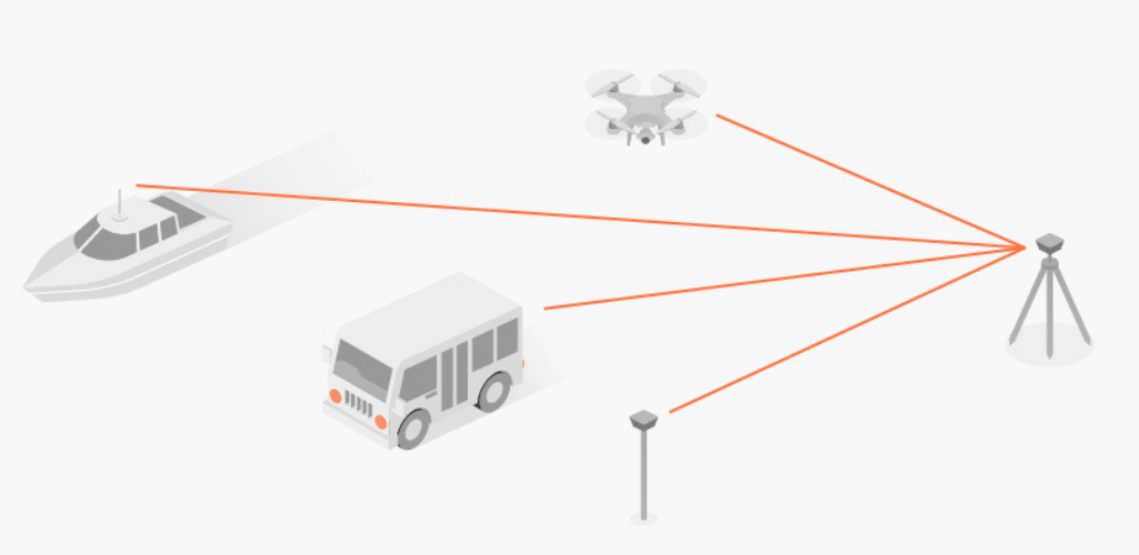
In the case of the two GNSS receivers, one unit is static - this receiver is called the base station. Examples include Emlid's Reach receivers or the DJI D-RTK 2 Base Station.
The other receivers is a rover and it can move freely. The difference between the two is called the baseline.

In the case of drone mapping, the rover is located on the aircraft - whether that's the built-in RTK module on UAVs such as the DJI M300 RTK or Phantom 4 RTK, or Emlid's Reach M+/M2 modules which can be integrated with the mapping drone.
For land surveying, Emlid's Reach receivers can be used as a rover, as well as a base station.
Any number of rovers can connect to one base if their input settings match the base's output.

The main difference between PPK and RTK is when the positional correcting takes place.
RTK mode applies all corrections in real-time during the data collection. In comparison, PPK resolves errors after all the data is collected.

Another difference between the two is that PPK enables a larger baseline, compared to RTK.
The table below shows the differences in distances, when using Emlid's Reach RS2 (multi-band) and RS+ (single-band) GNSS receivers as an example.
Single-band Maximum Baseline (Reach RS+) | Multi-band Maximum Baseline (Reach RS2) | |
RTK | 10 km (6 miles) | 60 km (36 miles) |
PPK | 30 km (18 miles) | 100 km (60 miles) |
Be aware that the longer the baseline, the higher the risk of accuracy errors, especially as atmospheric conditions can change across a larger distance.
You can find out the difference between multi-band and single-band receivers in our in-depth blog.
RTK: In Focus
As already mentioned, the RTK setup consists of two receivers: The first is the base receiver that's located over a known control point, and the second is the rover receiver that's moving and collecting data.
The base passes the information about its position and observes satellite data to the rover over the internet or radio. This information is called base corrections.
With these corrections and RTK algorithms, the rover receiver can exclude atmospheric errors and accurately calculate its position.

RTK enables this to be done in real-time.
However, during an RTK mission, the RTK module must stay connected to the base station while it’s gathering data in order for the two-way communication to inform positioning.
Unfortunately, signal loss can occur for several reasons: During turns due to antenna orientation, flying behind obstructions during drone mapping, patchy or unreliable signal, etc. When that happens, data becomes unreliable while the RTK module tries to regain contact with the base station.
RTK: NTRIP Corrections
It is important to note that you don't always need your own base unit for RTK. In most cases there are local service providers who have their own base stations.
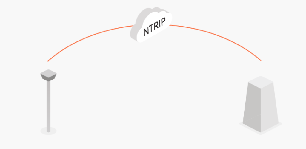
These stations can share their base corrections over the internet through a technology called NTRIP.

NTRIP is a good option for areas with strong 3G/LTE coverage and a vast network of NTRIP bases nearby.
In other cases, using the second receiver as a local base station has two advantages:
Autonomy in remote areas as there’s no need in the internet connection
Independency from local providers, no additional fees by NTRIP service.
PPK: In Focus
As mentioned previously, PPK is an alternative technique to RTK, whereby positional corrections are applied retrospectively.
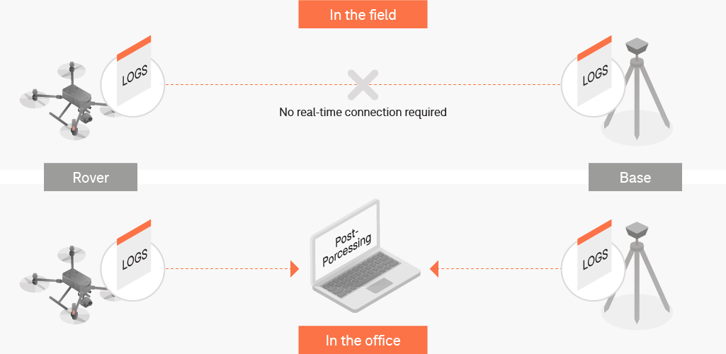
This means that, in PPK mode, there’s no need to have a connection between the rover and base station while you’re working.
You only need to record raw GNSS data (logs), which are then processed to receive an accurate positioning track and used for calculations in post-processing.
This is demonstrated by the two-step workflow diagram below.

The technique is widely used for drone mapping and for land surveying data collection. PPK can also be used as a back up for RTK for any surveying job.
The PPK Workflow
The PPK workflow is relatively straightforward.
You need to have a base station and a rover and both units should record raw GNSS data throughout the whole work process.
This raw data contains all observations without any calculations.
After the work is done, the logs from both the base and the rover are downloaded to a computer for further post-processing to achieve cm-level accuracy.

Remember, you don’t always need to have your own base station. In many cases, there are local service providers who have their own base recording logs. You can simply use their raw data for the same time frame as your work.
RTK Vs PPK: Pros and Cons
So, which correctional technique should you use during your surveys?
In truth, this depends on your specific mission, including network connections in the local area.
Either way, RTK and PPK have some distinct advantages and disadvantages, which might help make your decision a little bit easier.
These pros and cons are outlined below.
Pros | Cons |
RTK | |
* Correction complete immediately after flight. * Offers real-time, highly-accurate position of the drone. * Removes or limits the number of ground control points, if the connections are all constant throughout a survey. * Ideal for geo-tagging in absolute accuracy throughout flights in real-time * No GNSS post-processing necessary with real-time correction * Software, like EZSurv, is available to improve survey accuracy after the mission if the RTK connection drops mid-flight. | * Success of the mission depends on several technologies, thus is more prone to failure, requiring stable connection between GNSS base station or CORS network supporting VRS (via mobile network) to drone ground station, and then via telemetry link to drone. * Short-term loss of lock equals long time to re-initialise and more data lost. * No post-flight correction data available, i.e., flight area limited by signal strength. * Any error in the base station position must be corrected after the flight, which reduces real-time advantage. |
PPK | |
* Using PPK for drone mapping reduces the amount of ground control points you need. This saves you a lot of preparation time in the field and allows working on much wider and more difficult areas. * Provides a more reliable and simple workflow, because you don’t need to think of the constantly stable connection between the rover and the base. This makes it ideal for flights over larger areas. * Your GNSS base station doesn’t need to be connected to a drone ground station. * PPK also allows longer baselines: For instance, , multi-band GNSS receiver Emlid Reach RS2 and can work on distances up to 60 km in RTK, but a much longer 100 km in PPK. * Processing can be run multiple times using different settings. | * Correction happens after flight. * Additional time needed to process position data after flights have been conducted. * Easy to make mistakes in the workflow, which can cause a georeferenced shift or poor precision in the overall project output |
To discuss PPK and RTK in more detail and to introduce these surveying methods to your workflows, contact our in-house GIS/surveying team or learn more about heliguy™ survey assist.
